- The Marathon
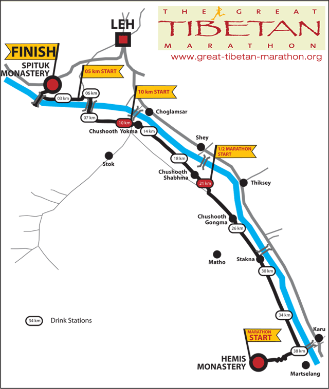
- Route Description
- Marathon Map
- About Ladakh
With its stunning trans-himalayan backdrop, the Great Tibetan Marathon offers an exceptional running experience. Located within the political boundaries of India, Ladakh - the western most province on the Tibetan Plateau - is also the last place where Tibetan Buddhism continues to thrive as a living religion.
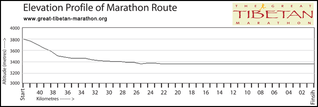
Running the distance of your choice at an average altitude of 3600mts (11,800 ft.), the Great Tibetan Marathon is undoubtedly the challenge of a lifetime. Forbes magazine selected the Great Tibetan Marathon as one of the “World's 10 most Extreme Marathons”.
There will be 3 running categories: The Full Marathon, Half Marathon and 10 km .
To avoid any serious altitude related sicknesses during the race, all runners are required to spend a mandatory 5 day acclimatization period in Ladakh at an altitude of 3500mts. All of the packages on offer conform to this norm.
The Marathon program, which is common to all of the different tour packages, is of two days. On the Morning of the 17th July 2010 is the Breakfast Run. This 3km morning run in Leh will help you gauge your fitness level, and give you a taste of the challenge the next morning.
On the morning of the 18th July, the Great Tibetan Marathon will begin to the sound of several long Buddhist horns from the courtyard of Hemis Monastery (3800mts). Hemis is the chief monastery of Ladakh region, and prior to the race the head Lama (priest) of the monastery will bless all of the participants.
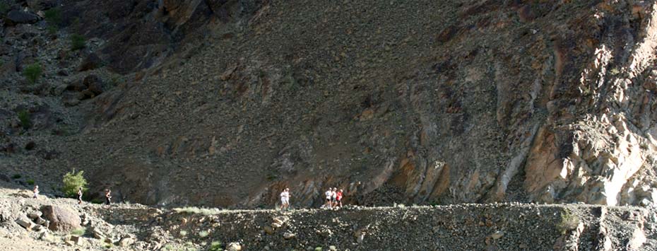
With the spectacular view of the Indus valley on offer, the marathon route is set at the foot of the Stok Kangri Range (6100mts). Throughout the track there will be several water and medical stops. Also, ambulances will be plying the track to take care of any emergencies. The track itself varies between tarmac, gravel, wooden bridges, village streets and is overall a good firm track. At the finish of the marathon, there will be a large medical tent with a team of doctors and nurses should you need any medical attention. The marathon finishes at the foot of the Spituk Monastery with a Buddhist celebration. Also at hand will be a team of masseurs to give you a rubdown.
The Marathon day ends with a Gala Dinner in a large marquee tent on the bank of the river Indus. The theme you ask? “1001 Tibetan Nights!”
Section no. 1:
Hemis: From the courtyard to the parking lot
The Great Tibetan Marathon starts form the Hemis Gompa (monestary), located at approx. 3800 meters above sea level. The monestary, which is one of the largest monestaries in the area, has a history of 350 years. The gompa has approximately 500 monks and they will be out in force today, either as participants in the ceremonies taking place before the race starts, or as helpers showing the way or manning the course stations along the route.
As part of the starting ceremony the race and all it’s participants will receive a blessing. And as we are standing on buddhist ground the race of course cannot be started with the usual shot from a pistol. Instead the start will be signalled by blows on the long Himalaya Horns – noone throughout the valley will be in doubt that the Great Tibetan Marathon has started. Before we make our way out onto the route a little practical information might be needed.
Course stations will be placed with intervals of four kilometer. As local conditions will determine the actual location of each course station they might be slightly off the eaxct 4-kilometer mark. Each course station will have water, a shaded area where it is possible to lie down should that be necessary, and toilet tents.
The distances are showed in kilometers. As the route are shared by both marathon, half marathon and 10-kilometer distances, the kilometer signs will be counting down from 42.195 km to zero rather than the other way round in order to avoid a confusion of signs out on the route. The distances in this route description will also follow this principle.
But now it is time to start the race!
From the starting line, which is placed in the middle of the courtyard right in front of the imposing main building of Hemis Gompa, the route exits the courtyard through a narrow gate at the end of the courtyard. 12 steps leads down to the gate witch has a very high threshold (a sign of the importance attached to the building inside the gate). From the gate two series of first 29 and then 15 steps leads to firm ground. From here a short stretch of dirt road leads on downwards to a small parking lot. Watch your step as you negotiate the steps, the gate and the dirt road to the parking lot - an accident at this point in time would be a sad end to one of the most spectacular marathons in the world.
Ahead lies 42 kilometers of surfaced and unsurfaced roads as well as narrow paths taking you through the barren mountain wastes of the Tibetan Plateau as well as the lush, green meadows along the Indus River.
Section no. 2:
From Hemis to Martselang
(42km - 37km)
When leaving the parkinglot you get onto sealed road, this could be the time to find a steady pace.
Remember that running at this altitude takes it’s toll so you should aim at a pace a bit slower than what you would normally do. And watch out. Even though the route is sealed there is still loose sand and gravel on the road.
From the Gompa a series of twists and turns takes you down through the small village below the monestary. Inside the village the road turns right across a small bridge, and the road continues down through the valley on the left-hand side of the small stream, which irrigates the lush fields of barley and rape below the village. We are still higher than the Indus and will be descending rapidly over the next 4-5 kilometers.
In the middle of the valley a long mani-wall – a stonewall with sacred inscriptions, said to be the longest in all of Ladakh, is leading the way down through the Hemis valley.
As the route gradually descends the green fields slowly give way to the barren foothills of the mountains, and the Indus Valley will gradually come into view. For now all you need to do is follow the sealed road that is taking you down the left side of the valley. After a while the route passes a Chorten on the right and crosses through the Mani-wall. As you pass through the wall there are no more fields, just a barren stone desert. In front is a clear view of KharuVillage and the Indus Valley.
A bit further down the route crosses the Mani-wall again and will be criss-crossing the foothills of the lower part of the valley. The road is sealed and in pretty good condition for these parts.
After approx. 4.7 km the route reaches the road that will take you through the Indus Valleytowards Leh and Spituk Gompa where the race will end. Take a left by the sign and the marshall - a few meters of dirt track leads on to the road running along the valley. We will be following this road for approximately 12 km.
Section no. 3:
Martselang to Chusod Shabma
(37km – 25km)
This stretch of road normaly sees little use and is in fairly bad shape. The road was originally sealed, but in sections the surface has been washed away by water comming down from the mountains in summer when the snow melts.
Just before reaching the 34 km sign (just over 8 km into the race) a small bridge leads across an irrigation ditch. At the time of writing a section of approximately 500 meters after the bridge were under construction, and the route will for this section be following a dirt track running parallel to the actual road.
From here it is straight ahead over the next 8 km. Conditions vary with some parts of the road sealed and some unsealed. As you run along you will be passing fenced areas belonging to among others the Regional Agricultural Research Station Skuast (on the right just before reaching the 30 km sign) as well as refor-restation projects.
Watch your step here! Small irrigation channels are digged randomly across the road by local farmers. The gompa that you can see on a hilltop to your right is the Stakna Gompa.
The road bypasses Stakna Gompa and village, which are on the right. This short section of road is unsurfaced. On the left will be barren stone desert, and on the right farmland and trees, mostly surrounded by low walls in adobe brick.
After passing Stakna we are back on a stretch of road that sees some more traffic, and is in a better state of repair, and so the going gets a lot easier. Right ahead on the other side of the river Thiksey Gompa can be seen perched on a hilltop. Enjoy the view as you run along this section of road.
Section No. 4
Chusod Shabma to Chusod Yokma
(25km - 12km)
By the 25 km sign the route turns right and leaves the surfaced road. A dirt road leads towards the center of the valley and into the village of Chushod Shabma. From the barren outcrops of the montains, the stone desert and the fenced off, poorly irrigated areas along the section of the route we have just completed, the route now takes us into the irrigated and more densely populated grounds feeding of the Indus River.
The start of The Great Tibetan Half Marathon will take place on this section just after Chusod Shabma. Starting from Chusod Shabma the route leads through a string of villages over the next 12 kms (8 km for half marathoners), and where the first part of the route from Hemis might have left one with a feeling of the desolation in these parts of the world, the section that we are about to enter now gives us the opportunity for a closer look and a more intimate feeling of the different people living in this area. Some of the villages are Tibetan others Moslem and as you run along you will be passing Chortens as well as small Mosques.
Between the villages are small fields surrounded by low walls made of adobe brick, planted mainly with barley and rape. Many of which will be harvested at this time of year – summers are short at this altitude. Trees planted along the road provides a bit of much needed shade and the villagers will be out in numbers cheering the partici-pants in the Great Tibetan Marathon & Half Marathon on.
After passing the 14 km sign the route will be passing a large prayer wheel on righthand side of the road, and shortly hereafter by the 12 km sign a large mosque. The route is now entering Chusod Yokma and the road ends in a junction and a row of small shops. This is the main road leading form the valley up to Stok which also has a large Gompa and where the descendants of the old royal family who used to rule Ladakh is now in residence.
On the right a heavily trafficed bridge leading across the Indus River to the main road through the valley and to Choklamasar Gompa. We choose to stay away from the highway – exhaust fumes from ramshackle old trucks carrying heavy overloads are unbearable at this altitude. Instead we turn right. For the next kilometer we still have some surfaced road, enjoy it while you can.
Shortly after the turn by a small stream and a turn-off leading to St. Peter’s School we will be passing the 11 km sign.
Section no. 5:
Chusod Yokma to Palam
(11 km – 8 km)
As the road leaves the village we leave the road. A sharp turn right takes us on to an unsealed road parallel to the course of the river. The route will be following this road for the next approx. 4 km. We will now be passing through a predominantly Ladakhi village with large, whitewashed houses spread out on both sides of the road. Chortens, prayerflags and small maniwalls re-minds us that we are truly on top of the world.
As the route leaves the village the road veers on below steep cliffs on the left and irrigated areas with trees, houses and fields on the riverside to the right.
We have now reached the starting point of the 10-kilometer distance. As the road start climbing Spituk Gompa, where the race will end, comes into view up ahead - we still have quite a distance to go before that though.
Between the 9 and 8 km signs the route passes two chortens and are closing in on the point where the route will leave the main road for smaller tracks and paths.
By the 8 km sign we reach Palam Medical Center on the left-hand side. Here the route turns away from the road (the turning point is marked by signs and marshalls) for small tracks and paths taking us down towards the Indus.
At the medical-center take a sharp right and follow a narrow path between walls seperating the fields. A short descent along a narrow track takes us in between whitewashed Tibetan houses. Follow the track to the right and then left past a small, whitewashed Chorten. As you are running on private property please respect the surroundings, do not litter or pee here.
Section no. 6:
Palam to Spituk Gompa
(8 km – finish)
At the medical-center the route turns right and follows a narrow path between walls seperating the fields. A short descent along to a narrow track between high walls, leads in between whitewashed, Tibetan houses. Follow the track to the right and then left past a small, whitewashed Chorten. As we are now running on private property please respect the surroundings, do not litter or pee here.
Having passed the houses the route leads through a small gate (several marshall will be posted along this section showing the way and keeping the gates open and the livestock in place) and continues along narrow paths between small fields. The next 500 meters the route will follow this path winding through fields and small farms before reaching two small wooden bridges and an open meadow. On the far side of the meadow (approx 200 meters) is a small, white building with a prayer wheel – aim for that!
In case you are in need of a helping hand spinning the prayer wheel a few times might help.
Otherwise a break on the edge of the stream might give you renewed energy. Upon passing the prayer wheel we carry on along a short section of very uneven cobbled road – watch your step! Luckily it is only a short run before reaching a wooden suspen-sion bridge, draped in prayer flags (protecting the bridge and those crossing it). This crossing will be the first of three times that we will cross the Indus River during the race. The 6 km point is on the bridge.
Cool winds blow along the river so maybe a short break to enjoy the beautiful view from the bridge is not such a bad idea.
Coming of the bridge you get on to a section of surfaced road. Take your time to enjoy it while you can – we will only be following it for a short distance.
After another few hundred meters on surfaced road, the route reaches a draining ditch leading towards the river. Turn left by the bridge and follow the marked track towards the river.
By the river the route follows the Indus and will now be leading through lowlying green (and wet) areas with grazing goats, sheep and cows. As we run along, a small building surrounded by trees will come into sight. A course station will be located here as well as a bit of much-needed shade for a short break should that be needed.
Having crossed meadows, small streams and in some places fields the route finally leads on to the river bank itself and for a while the running will be on the river bank itself. Up ahead a small Hindu temple is located right on the bank of the river. Here we cross narrow teel bridge and carry on along the riverbank. A few hundred meters from here the path meets up with a dirt road. Up on the right is Spituk Gompa and and the finishing line, but first we will be making a short detour.
Where the path meets the dirt road the route carries on straight ahead following the course of the river. A few hundred meters further on the route turns right and another hanging bridge (this one actually carries cars) takes us across the Indus one more time.
Stay on the left side of the road and follow the directions of the signs and the marshalls. We will be coming back the same way so you might meet runners coming in the opposite direction on this part. Having passed the bridge the route carries on for a short distance before making a Uturn and going back the same way, this time staying on the dirt road leading away from the Indus towards Spituk.
From the river the route leads into the village below the Gompa. We are entering the final leg of the race and the number of spectators will increase. The road – still unsealed – leads into another village. Follow the directions given by the signboards and the marshalls and turn right towards the Gompa itself. On the lefthand side will be a small field surrounded by stone walls, on the right chortens and mani-walls.
The route is now following a paved but rather narrow footpath skirting the edge of the hill on which the main part of the Gompa is located. Follow the foot-path ahead passing Chortens, prayerflags and tibetan-style houses. Look out for the large rock on the right with colourful Buddhist inscriptions and paintings.
Having passed below the Gompa we reach the limits of the village. Up ahead are open fields and a view back along the Indus along the route that we have been running. Instead of leaving the village we turn left into a small passage taking us below a small Chorten built across the assage.
The route follows the passage, which gradually widens and leads on to a proper road. Now we should be able to hear the tones of traditional Ladakhi music. The finishing line is only a few hundred meters away so now might be the time to lift the head and pick up a bit of speed for the final bit. Follow the sound of the music, turn right through the gate – and this is it!
On the middle of the courtyard right in front of the Hall is the finishing line – cross it and you have completed The Great Tibetan Marathon, Half marathon or 10 Kilometer run.
The medal is yours to keep!!!
Ladakh is a land of staggering beauty and unearthly proportions, set amongst some of the world's highest peaks. With scenery ranging from lunar landscapes to fertile plains, and inhabited mostly by Buddhist subsistence farmers, Ladakh seems a world away from the rest of India. One of the most elevated inhabited regions in the world, it is surrounded by the majestic snow-capped peaks of the Himalayas, which tower over the patchwork of green village fields fed by glacial snow melt below. With all this still largely untouched by urbanization, Ladakh transports you to another world and another era.
Leh, the capital of Ladakh and our central base for the Great Tibetan Marathon, is a bustling little town that is dominated by the ruins of the ancient castle perched above the main bazaar. People are extremely friendly and are quick to say "Julley!" (hello). Village women sell vegetables along the main bazaar, laneways are studded with stupas, and green agricultural fields form a tapestry above the town – all making Leh a lovely place for walking and exploring.
Around Leh are several ancient gompas (Monasteries) such as Hemis, Thiksey, Spituk and Phyang. The gompas are all different and all fascinating. You will see the lamas (monks) both young and old as they go about their daily rituals and prayers.